Dog Mountain
Wildflowers • View
Trail Stats: 7 miles round trip // Level: Most Difficult // Elevation Gain: 2,948 ft
PLEASE NOTE: Spring weekend hiking permits are now available for Dog Mountain. Every hiker on the Dog Mountain Trail system on Saturdays and Sundays between April 24 to June 13 (as well as on Memorial Day) will be required to carry a permit (or digital proof thereof).
There are two ways for hikers to obtain permits:
- Ride the shuttle from Stevenson. A permit is included automatically with the Skamania County Transit bus from 518 Rock Creek Drive, Stevenson. Seats are available on a first come, first served basis. In lieu of the previously required fee, donations will be accepted. Each permit is good for one individual on the day it is issued. The shuttle runs about every 30 minutes from 7:30 a.m. to 5:00 p.m. on weekends from April 24 to June 13. The last shuttle to depart Stevenson will be 1:00 p.m. and the final shuttle departing the trail head will be at 5 p.m. Shuttle capacity will adhere to current CDC physical distancing requirements and follow the Washington State Mask Mandate in place.
- Reserve a permit online. Anyone not taking the shuttle will need to reserve one permit for each person online at www.recreation.gov and pay the $1.00 non-refundable administrative fee (per person) in addition to paying the recreation site fee of $5 per car. Valid Northwest Forest or interagency federal passes are accepted (but not state parks passes) as a form of paying the recreation fee but are not a substitute for having the per person permit.
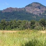
A very popular trail, particularly from mid-April through early June, when the hills are filled with blooming wildflowers. Hikers will also see impressive views of Mount St. Helens, Mount Adams and Mount Hood. The trail is somewhat challenging as it gains 2,948 feet in elevation and is 3.5 miles to the top. Plan four hours to hike this one and take water and food for the break on top! This heavily used loop opportunity climbs rapidly in the first 0.5 mile, gaining 700 feet in elevation. The trail forks, giving hikers the option of heading north on the more direct, but steep route to the summit, or to the east for a longer but more gradual climb. The trail to the right (east) provides a great opportunity for sweeping views of the Columbia River and beautiful flowered meadows, while the northern route is a 2.5 mile steep grade through the forest where it links back up to the summit loop trail. Watch for poison oak and rattlesnakes along the trail.
Driving Directions:
To reach the trail, travel 10 miles east of Stevenson. After mile post 53 on Highway 14, there is a large dirt parking lot on the north side of the highway and a sign marks the trailhead.
10 miles from Stevenson, WA
NOTE:
NW Forest Pass required.

Leave No Trace
By submitting this form, you are consenting to receive marketing emails from: . You can revoke your consent to receive emails at any time by using the SafeUnsubscribe® link, found at the bottom of every email. Emails are serviced by Constant Contact


Skamania County Chamber of Commerce
Follow us at
Web Cam / Weather / Maps
Thanks to our funding partner
![]()
For more info on surrounding areas in the Gorge, visit our regional partners


