Lower Falls Creek

Waterfall
Trail Stats: 4.4 miles round trip // Level: Easy to Moderate // Elevation Gain: 800 ft
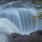
A 2.2 mile hike takes you to the lower level of the spectacular Falls Creek waterfall. Start the hike by crossing the cable suspension bridge which spans a rock gorge providing spectacular views of the white water of Falls Creek. The trail follows Falls Creek, climbing through a 50- to 60-year-old forest for about 1.5 miles. Continue uphill for 0.7 mile to the base of the waterfall. The trail ends at the waterfall. There is a creek crossing prior to the falls. The delicate mist from the cascades of Falls Creek creates a cool peaceful environment for relaxing at the end of the trail. There is also a hike to the Upper Falls by following this road for 2.5 miles to the trailhead. The grade of the trail slowly climbs away from Falls Creek and crosses two creeks before reaching the waterfall in about 2.5 miles. The trail flattens out for about .75 of a mile where it meets road #6503 and ends. Falls Creek surges over rocks and timber, cascading from a height of about 100 feet.
Driving Directions:
Take State Highway 14 east to Carson. Go through the town and continue north on Wind River Road #30 to Forest Rd #32062-057. Turn right and follow the signs to Lower Falls Creek Trail #152A.
18 miles from Carson, WA
NOTE:
NW Forest Pass required.

Leave No Trace
By submitting this form, you are consenting to receive marketing emails from: . You can revoke your consent to receive emails at any time by using the SafeUnsubscribe® link, found at the bottom of every email. Emails are serviced by Constant Contact


Skamania County Chamber of Commerce
Follow us at
Web Cam / Weather / Maps
Thanks to our funding partner
![]()
For more info on surrounding areas in the Gorge, visit our regional partners


